It’s a long way to New Zealand and, yes, the flight is hell: it’s expensive, it’s long, and there is nowhere to put your legs. Flying out of Munich, it takes about six hours to Dubai and then another 16 to Auckland. But when you arrive, the world has, literallybuchstäblichliterally, been turned upside down. What you knew as 12 midnight has become 12 noon; you drive on the left-hand side of the road instead of the right; and, most importantly, it’s no longer winter, but summer — or the other way round.
As we land in Auckland, we are welcomed by sunshine. My aunt picks us up. It’s far too dangerous to drive directly following such a long flight. After a few days of to catch up with sb.jmdn. treffen, mit jmdm. Neuigkeiten austauschencatching up with friends and family, we head down to Queenstown on the South Island.
Queenstown, probably New Zealand’s most famous city, is nicknamedmit dem Spitznamennicknamed “the adventure capital”. The world’s first commercial bungee jump was set up here in 1988, and jetboatingStrahlbootfahrenjetboating was invented by a Queenstown farmer. Now the number of high-adrenaline activities is mind-blowing (ifml.)überwältigendmind-blowing: skydiving, parasailing, zip lining, white-water rafting — the list goes on.
Ready, steady...
We’re here for only a day this time, so we decide to take it easy and walk up Bob’s Peak. The view of the city, the lake and the mountains is great, but it’s almost impossible to stay out of other tourists’ photographs. In the evening, the restaurants are crowded, too, so we do the Kiwi thing and eat takeaway fish ’n’ chips by the lakesideSeeuferlakeside.
The next morning, a minivan takes us to Clyde, a small town in the Central Otago region. “Central”, as the Kiwis call it, is known for its hot, dry summers and cold, dry winters. Both the highest and the lowest temperatures ever recorded in New Zealand were measured here. It’s the perfect place to grow stone fruitKernobststone fruit such as peachPfirsichpeaches and plumPflaumeplums, and it’s also becoming more and more known for its wines, particularly Pinot Noir. But outside the tourist towns of Queenstown and Wanaka, the population is sparsedünn, spärlichsparse.
This wasn’t always the case. In the 1860s, the Australian prospectorGoldsucher(in)prospector Gabriel Read discovered gold in a creek bedBachbettcreek bed about 80 kilometres west of the city of Dunedin. A huge gold rushGoldrauschgold rush followed. At its high point, 18,000 minerBergarbeiter(in)miners were trying to find their fortune in Central Otago. Apart from a lucky few, the people who made the most money were not the miners, but those who provided them with food, water, accommodation, banks, post offices, pubs and transport. In 1879, the construction of a railway line from Dunedin, the main starting point for miners, to the gold towns in Central Otago was begun. It took 28 years until it reached Clyde. The train transported both people and freight: mostly livestockVieh, Nutztierelivestock, wool and fruit.
As the gold ran out, the population dropped again. Trains were used to transport material for the construction of the Clyde Dam in the 1980s, but in 1990, the railway line was closed, and the tracks were removed. Only a small section remains between Dunedin and Pukaki — the Taieri Gorge Railway, which is now a tourist attraction.
The tracks left behind a wide 150-kilometre path without steep inclines. In 1993, New Zealand’s Department of Conservation decided to buy the rest of the track and turn it into a bike trailRadwanderwegbike trail. Bridges were repaired, and handrailGeländerhandrails were added. The department improved the surfaceOberflächesurface and made sure the old tunnels were still safe. The Otago Central Rail Trail became the first of what are now known as “New Zealand’s great rides”: bike trails throughoutüberall inthroughout the country. If this sounds familiar, you might be thinking of “New Zealand’s great walks”. These are the most famous walking trails in the country, including the Milford Sound track and the Tongariro Crossing.
...go!
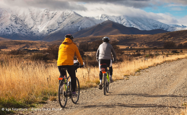
The rail trail begins in Clyde, about an hour’s drive from Queenstown. Here, we collect bikes and helmetHelmhelmets from Trail Journeys. They have organized our bike trip for us, booked our accommodation, and they will be taking our luggage from one place to the next. Because we are going on a wine tour with them that afternoon, we have to bike only to Alexandra today — either eight kilometres on the rail trail or twice as far along the river track. We decide to take the river track.
By the time we leave Trail Journeys in the direction of the Clutha River, it is 10.45 a.m., and the sun is burning down. Luckily, the bankhier: Uferbanks of the river are covered in trees, so we bike mostly in the shade. We see few other people on the way, and the only sounds we hear are from birds, insects and our bike tyreReifentyres on the track. We take our time, stopping often to photograph or to sit and watch the bright blue water flowing slowly by. A family of quailWachtelquails crosses the track in front of us, and we stand very still, watching the funny little tuftBüscheltufts on their heads to bobtanzen, hüpfenbob up and down.
At 12.30, we arrive in Alexandra. With a population of 5,000, this is one of the largest towns in the area. As in most New Zealand towns, many buildings have only a ground floor, and the main street is very wide. This means you can see a lot of sky. We check into Asure Avenue Motel and have a chat with the owner, David Burke. He’s full of anecdotes about the area.
Then it’s time for our wine tasting at Como Villa vineyardWeinberg, Weingutvineyard. Owners Johnny and Pam Chapman have restored an old stone house built by an engineer who made his fortune in the time of the gold rush. We are on our second tasting and in the middle of chatting to Pam, when Johnny walks in. He’s a stockystämmig, untersetztstocky, energetic man with grey hair and lots of wrinkleFalte, Fältchenwrinkles from the strong Central Otago sun. He has a loud laugh. It’s hard work, he says, so you have to enjoy the rewards.
On the way back to the motel, our driver stops at a fruit shop. We buy a big bag of local cherries and apricots. We add some bread and cheese from the supermarket and eat like kings as the sun sets on our motel terrace.
Danger and a beastly hill
The next morning, we leave our luggage at reception for Trail Journeys and get on our bikes again. From now on, we’ll be following the Otago Central Rail Trail, starting at what used to be Alexandra Station.
At first, the trail takes us through hilly terrain, cutting through the schistSchieferschist rock and rising slightly, then becoming flat and leading past Galloway. A small wooden hut still stands at the side of the trail here: the ladies’ waiting room. Women used to wait inside it for the train, safe from the weather and, well, from men. Now, passing cyclists can stop by to read the information boards inside and have a rest before they move on.
Over a wooden bridge, we cross the Manuherikia River and follow it for a while. The area is very dry, but the banks of the river are rich with green trees and bushes, providing homes to all sorts of birds and insects.
We’ve already biked 17 kilometres by the time we reach Chatto Creek. As well as a few small buildings and a cafe with an old gold dredgeBaggerdredge displayed in a field out in front, there’s a hotel. Gold dredges were developed to extract gold from the rivers. In the 1890s, New Zealand designs were so successful that they were even exported. We also have a look inside what used to be the country’s smallest post office — a tiny hut that offers room for only about three people. It was run by the same woman for 32 years.
After lunch, we cycle right into a headwindGegenwindheadwind for about four kilometres across a flat stretch. There are fields on both sides, happy cattleRindercattle and wild purple flowers amongst the grass. The track rises to Tiger Hill, the steepest part of the trail. Because it was originally built for a steam train, it’s not actually that bad: the inclineSteigungincline is 1:50, or a two per cent rise in elevationHöheelevation.
On the other side of the hill, there is still no shade in sight, but the land is a bit less dry. Sheep stand on areas of greenery here and there. We take a two-kilometre detourUmwegdetour from the track to the town of Ophir, which was once the biggest gold-mining town in the valley. There’s nothing much to see now apart from a few quaintmalerisch, reizendquaint historic buildings.
From the remainsÜberreste, Ruinenremains of the Omakau railway station, it’s only another seven kilometres to Lauder. We’ve come 42 kilometres today and will be spending the night in what used to be Lauder’s school. The owner, Bruce Macdonald, has booked a table for us in the restaurant across the road. The food is locally sourcedaus regionaler Produktionlocally sourced, homemade and absolutely delicious — especially the dessert: sticky date puddingDattelkuchensticky date pudding. It’s just the right way to end a day’s cycling.
Storm and a hot shower
The sky is overcastbewölkt, bedecktovercast on the morning of day three. After about half an hour of biking, we arrive at the trail’s first tunnel. We leave our bikes at the entrance and to clamberkletternclamber down the hill to the remains of a camp. It was set up by the workers who built the track and tunnels. Only a few stone chimneys and foundations are left.
The two tunnels are so long that we have to use torchTaschenlampetorches. On the other side is the Poolburn Viaduct — at a height of 37 metres, the tallest bridge on the trail. Then the hills disappear into the distance for a while. Here and there, we notice a fruit tree growing right beside the track. Where do they come from? Well, have you ever thrown an apple coreApfelgehäuseapple core out of a car window and wondered whether it would ever grow into a tree? That’s exactly what the train passengers did.
At just after 1 p.m., we arrive at Hayes Engineering Works. Ernest Hayes was an engineer who invented tools for farmers that are still in use today — the most famous one is used to to tightenfestmachen, festziehentighten the wire on fences. We take our time exploring the old workshops and the homesteadGehöfthomestead.
Two hours later, we leave Hayes and ride for another hour before the rain comes to pour downin Strömen gießenpouring down. Every few kilometres, there is a small, red metal shackHütteshack at the side of the trail: a ganger (UK)Vorarbeiterganger’s shedSchuppenshed, used for shelter by those who worked on the railway. It’s a good place for a quick rest, and the information boards inside provide all sorts of interesting facts about the surrounding area.
We hide in one of the sheds for a while, but the rain continues, so we have to move on. We pass the trail’s highest point at 618 metres (the starting point in Clyde is at 170 metres), and then it’s downhill through the pouring rain. By the time we arrive at Hawkdun Lodge in Ranfurly, we are wet right through. Time for a hot shower, dinner and bed.
Sun and endless sky
The last day is also our longest: we’ll be riding a distance of 60 kilometres, making it a total of 172 in four days. Luckily, it’s mainly downhill, and the rain has cleared. We start out at 9.30 a.m. and speed along happily, passing fields with purple flowers, green farmland and great views of the distant mountain rangeBergkette, Bergzugmountain ranges.
At noon, we arrive at Prices Creek Tunnel. We walk along a track to the left of the tunnel and discover one of the most spectacular views of the trail: below, the Taieri River to windsich windenwinds through a rocky gorgeSchluchtgorge linedgesäumtlined with trees and scrubGestrüpp, Unterholzscrub. Hills of dry tussockGrasbüscheltussock stretch into the distance, and a few white clouds dot the perfectly blue sky.
After this, the track is much flatter. As the kilometre count on our speedometerTachospeedometer nears 170, we slow down. In a few minutes, we’ll reach Middlemarch, the end of the trail. We’ll give our bikes back to Trail Journeys and see some more lovely views of the river from the historic train along the Taieri Gorge Railway to Dunedin. But as we near Middlemarch, we wish we could just keep cycling: so much sky, air, light and nature, and so few people! Exploring New Zealand by bike is one of the best ways to do it.
If you go…
Getting there and around
Fly to Auckland or Christchurch and then on to Queenstown with Air New Zealand or Jetstar. You can take a bus to Clyde with Intercity or Nakedbus, but most companies servicing Otago Central Rail Trail will drive you from Queenstown.
Where to stay
Asure Avenue Motel, Alexandra. www.asurealexandra.nz
Lauder School B&B. www.lauderschool.co.nz
Hawkdun Lodge in Ranfurly. www.hawkdunlodge.co.nz
Cycling
Trail Journeys. www.trailjourneys.co.nz
For more tour operators, see otagocentralrailtrail.co.nz/tour-operators
More information
Neugierig auf mehr?
Dann nutzen Sie die Möglichkeit und stellen Sie sich Ihr optimales Abo ganz nach Ihren Wünschen zusammen.