Day 1
4 p.m.
The half-hour Uber ride from San Francisco is quick and cashless. The sharing economy’s original brand of taxi ride was created here, and it to work like a charmwunderbar funktionierenworks like a charm. My husband and I pick up a rental RV (recreational vehicle) (N. Am.)WohnmobilRV in San Leandro, a suburb, before driving on to Sacramento, the state capital of California and where US Route 50, the inspiration for this road trip, begins.
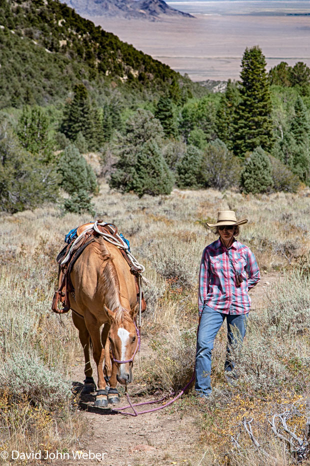
Route 50 runs 5,000 kilometers across the country, through 12 states, ending at the sands of the Atlantic in Ocean City, Maryland. It has been called “one of the last intact transcontinental highways,” though newer roads to overlapsich überschneidenoverlap and to obscureverdeckenobscure its path. In the 1980s, Life magazine nicknamed Route 50’s poorly populated Nevada segment “The Loneliest Road in America.” Since then, hikers and Harley enthusiasts have made it their own. History buff (ifml.)Fanbuffs visit, too, for its ghost towns and because it follows part of an old mail route, the famous Pony Express.
Daylight to dimsich verdunkelndims to gold. Driving over the state line into Nevada, there are no cars. None. Just sagebrushSalbeistrauchsagebrush steppe and foothills.
We take a detourUmwegdetour on State Route 722, and a coyote to zip (ifml.)huschenzips over the road. Soon after, close to Carroll Summit, we see a turnoutHaltebuchtturnout flat enough to serve as a campsite. This seems to be BLM land — land administered by the federal government’s Bureau of Land Management — so “boondocking,” RV camping without hookups to electricity and water, is allowed here.
Standing outside the camper, I look up at the moonless night sky. The Milky Way seems close and bright, as if you could step into it, maybe catch a ride on a shooting starSternschnuppeshooting star. Satellites blink past, offering an alternative lift out to the unknown.
Day 2
6 a.m.
It was a cool night at 2,000 meters. I switch on the heat, make coffee, and look out the window. Luckily for me, the rabbitKaninchen-rabbit show has just begun: A big hare(Feld-)Hasehare hophoppelnhops out of the sagebrush and finds a spot in the sun. The first rays of light shine through his long, black-tippedmit schwarzen Spitzenblack-tipped ears, turning them a warm, translucentdurchscheinendtranslucent pink.
8:40 a.m.
The drive out of the mountains is curvy, but before long, the RV to emergeherauskommenemerges onto a deserthier: verlassendesert straightaway (N. Am. )Geradestraightaway. Through the windshield (N. Am.)Windschutzscheibewindshield, the “loneliest road” lies like a straightedge ruler(Kanten-)Linealstraightedge ruler on the wide, flat valley floor. When the land begins to rise again, the road pushes its strong, insistent line right up the next mountain range.
Variation in the desert comes in many forms: a broad white salt flat, heat rising from it; a truck painted in beige camouflage, a clue that Naval Air Station Fallon — home of the Topgun flight school — is out here. Wild mustangs hold nervous meetings well away from the road and, for us, there are places to stop and see ancient petroglyphFelsenzeichnungpetroglyphs. Farther on, signs announce the Yomba Shoshone Indian Reservation and a mine called Gold Venture. Then comes Austin, population 192. We stop here, at the International Cafe on Main Street, for a cold root beer (N. Am.)Limonade aus Wurzel- und Kräuterextraktenroot beer.
3 p.m.
A big supermarket is a rare sight on Route 50. The mining town of Eureka has one, so we stop and fill the RV fridge. Ninety minutes on, we’re in Ely, once a stagecoachPostkutschen-stagecoach station on the Pony Express route. A gas station here distinguishes itself by having a (since 2017 totally legal) marijuana dispensary(Arznei-)Ausgabedispensary next to it. I’m too chicken (ifml.)feigechicken to go in. Plus, we’re getting close to the natural high at the end of this part of Route 50: Great Basin National Park.
Day 3
8 a.m.
Standing on a picnic table, I can see them: four antelope about 500 meters out. These pronghornGabelbockpronghorns are to strategizeplanenstrategizing. They want to get at the green grass on the other side of a farm fence. They must have reached a decision, because now they slipschlüpfenslip under the barrier single fileim Gänsemarschsingle file and disappear.
Our ad-hoc campsite is the parking area of Baker Archeological Site. We arrived too late for a space in its famous neighbor, Great Basin. “Never mind,” a local told us. “You can ‘dry camp’ out there.” Baker is on public land, so we’re set for the night, minus any hookupAnschlusshookups to power and water. It’s boondocking once again.
The Baker site is in the green Snake Valley in the shadow of the Snake Range. Posters about the ancient native Fremont culture decorate its covered picnic area, and a trail leads to the archeological site. There, the outlines of homes appear among the low greasewoodSarcobatusgreasewood shrubs.
In the 1200s, the Fremont built adobeLehm-adobe houses and granaryGetreidespeichergranaries here. It is thought that they tracked the seasons by observing how the sunlight fell on their buildings, some of which were to alignausrichtenaligned with the winter and summer solsticeSonnenwendesolstices.
9 a.m.
After breakfast, a short drive takes us to Great Basin National Park. At the visitor center, the ranger directs us to the nature displays and a small theaterKinotheater. Here, I learn that there are four major deserts in North America, and that the Great Basin Desert is the only cold one, freezing in winter and receiving a good bit of its precipitationNiederschlagprecipitation as snow. In the 1830s, American explorer John C. Frémont recognized that while water flowed into this region, it did not flow out, and gave this enormous inland drainageEntwässerungs-, Abfluss-drainage system its name. The Great Basin is big. It extends from California’s Sierra Nevada range to Utah’s Wasatch Mountains and to compriseumfassencomprises, as I learn, 90 desert basins separated by 160 mostly north-south mountain ranges. Nevada is at its heart: The state name in Spanish means “snow-covered,” a reference to its numerous white peakGipfel, Spitzepeaks.
11 a.m.
The RV rolls into Baker Creek Campsite, a proper place to hook up the RV and camp in Great Basin National Park. Our elevationHöheelevation is 2,350 meters, and we have plenty of what makes camping in the US so sereneruhig, entspanntserene: space. Our closest neighbor is 30 meters away. Sitting at the kitchen table, I read the park information sheet. People come here to see 3,000-year-old bristlecone pineBorstenkieferbristlecone pines, a night sky that’s been named an International Dark Sky Park, the Lehman Caves stalactites, and Wheeler Peak Glacier. A knock comes at the camper door. I get up to see who’s there.
I step outside and soon see the sourceQuellesource of the loud knocking sound: it’s a big wild turkey. The male bird, tail feathers spread out in a fearsomefurchterregendfearsome fanFächerfan, is hammering at its reflection in the chrome bumper (N. Am.)Stoßstangebumper. A harem of hens watches in fascination. I wave them away with a laugh. The expression “birdbrain (ifml.)Spatzenhirnbirdbrain” has to come from somewhere. Time for a sandwich in the RV.
4:10 p.m.
With water and rain gearRegenkleidungrain gear in our packs, we make our way to Baker Creek trailPfad, WanderwegTrail. At the trailheadAusgangspunkt des Wanderwegstrailhead, we sign the park register — for safety, and to make the start of the hikeWanderunghike feel official. Small wooden bridges take us over streams and past aspenEspeaspens. Just ahead, two large deerReh, Rotwilddeer are on the path. Slowly, the animals move off into the forest.
Day 4
8 a.m.
The turkeys march past the camper again, this time without incidentVorfallincident. Today, nature has a new act, too: a gang of pinyon jayNacktschnabelhäherpinyon jays, also called “blue crowKrähecrows,” in the trees outside the camper. One works a pineconePinienzapfenpinecone like a lion with a fresh kill; it complains loudly when other birds come too close.
We have another hike planned, this time, a four-hour route on the Pole Canyon Trail. On the way to the trailhead, we pass campers drinking coffee. They live near Lake Tahoe, on the California border.
“There are two things people don’t realize about Nevada,” one of them says. “It’s the most mountainous state in the lower 48 [the contiguouszusammenhängend; hier: kontinentalcontiguous US] and has the largest forest in the lower 48.” My idea of Nevada used to be Las Vegas. Route 50 has shown me a completely new side to the state.
3 p.m.
After the long, quiet hike in the woods, we stop at the visitor center. I buy a book about the park, turn around, and meet its author: Gretchen Baker, Great Basin National Park ecologist. “When I go to the city, I can’t wait to get back out here,” she says. “The isolation really to grow on sb.jmdm. ans Herz wachsengrows on you.” I ask her if she has ever seen a mountain lion in these parts. “Just once,” she says. That would be one time too many for me, I say. We laugh and wave goodbye.
That evening, I look forward to another night of deep, uninterrupted sleep in the RV. It’s a terrific way to travel: slowly, like a snailSchneckesnail with its house on its back. At times, this house has little internet access and miserable phone reception. Perfect.
Day 5
11:30 a.m.
To cross into Utah, Nevada’s neighbor to the east, is to travel through time. You lose an hour simply by going from the Pacific to the Mountain time zone (for example, from 1 p.m. to 2 p.m). Expectations change here, too, as many of the country’s best-loved national parks are in this state. As in Nevada, distances are great, so we ready ourselves for a full day of driving. Soon, we’ve left US 50 and are driving southeast into Utah, “the Mormon state.”
2:30 p.m.
After passing through a dust storm on Interstate 15 near a place called Parowan, a former outpost of Mormon pioneers, we reach Cedar City, home of Southern Utah University. At 30,000 people, this is, for the region, a big city. We eat burgers at the All American Diner on Main Street, a tip from a local. People here, many of them Mormons, are very friendly. It’s a big plus for travelers.
4:30 p.m.
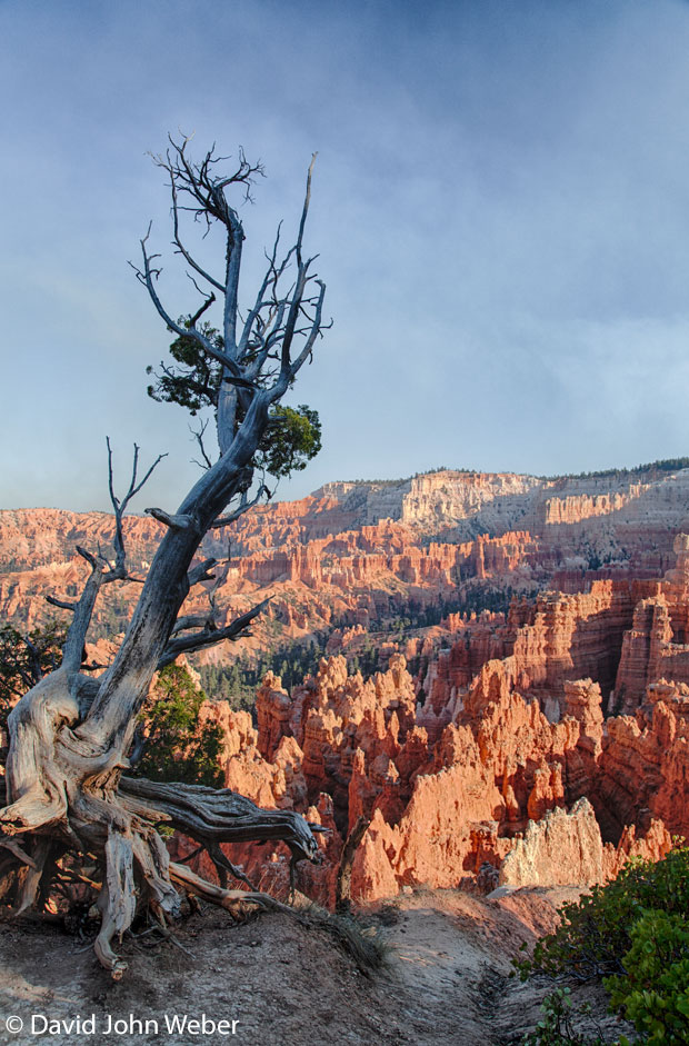
We stop at Cedar Breaks National Monument, a spectacular amphitheater of red cliffs, and push on to our campsite at Kodachrome Basin State Park. When we arrive, we drive the RV to our reserved spot, lock up, and walk to Angel’s Palace Trail. To see the park’s 67 red rock spireFelsnadelrock spires against the dark blue sky is to enjoy the uncomplicated beauty of desert contrasts. In 1948, this effect inspired the National Geographic Society to give the park its corporate-sounding name.
Kodachrome sits on the Colorado Plateau, a place of rich and ancient geology that to spanumfassenspans the “four corners” area of Utah, Arizona, New Mexico, and Colorado. The Grand Canyon is its crown. Bryce, a national park not far from Kodachrome, is another priceless treasureSchatztreasure.
8:30 p.m.
Luxury showers at Kodachrome provide a break from the tight but functional shower in the camper. After that, it’s tacos prepared in the camper kitchen and cold beer under the stars by the campfire. The park’s sandstone monoliths, some 52 meters high, go black against the sky.
Day 6
4:30 p.m.
The drive to Bryce Canyon National Park takes 30 minutes. Restaurants and hotels crowd the park entrance. We leave the RV in a big parking lot near them and ride a park bus to Sunset Point.
Asian tourists in smock-likekittelartigsmock-like shirts stand at the rimRand, Kanterim of the massive canyon. A Frenchman hurries by, large camera held aloftin die Höhealoft, while Midwesterners take selfies (with the natural wonder as a useful backdropHintergrund, Kulissebackdrop) while kissing. Behind them, big black ravenRaberavens ride the warm wind rising from the canyon walls. They call out as if to let us know that the sunset performance is about to begin.
Bryce’s natural amphitheater is filled with countless hoodoo (N. Am.)Felspfeilerhoodoos, the geologic approximation of a thousand Buddhist monkMönchmonks in orange robeGewandrobes. The color intensifies to dark red in the dying light, a display of our planet’s serenity I’ll not soon forget.
If you go
Getting there
Fly to San Francisco (SFO).
Renting an RV
Book an RV through CRD.
National parks
Buy an “America the Beautiful” pass for access to all national parks.
www.nps.gov
Planning
Reserve campsites well in advance. Some operate on a first-come, first-served basis. It is also possible to camp on BLM public lands, often at no cost. Careful, though: Detailed trip planning is important for this kind of journey.
Try roadtrippers.com
More information
Neugierig auf mehr?
Dann nutzen Sie die Möglichkeit und stellen Sie sich Ihr optimales Abo ganz nach Ihren Wünschen zusammen.